This article has been reviewed according to Science X's
editorial process
and policies.
Editors have highlighted
the following attributes while ensuring the content's credibility:
fact-checked
trusted source
proofread
Remote sensing tools yield insights into abandoned pre-Columbian Mexican city
View of Guiengola's North Plaza from above. It is the only area not covered by a canopy of trees. Credit: Pedro Guillermo Ramón Celis
A McGill University researcher has discovered that Guiengola, a 15th century Zapotec site in southern Oaxaca, Mexico, which had been thought to be simply a fortress where soldiers were garrisoned, was in fact a sprawling, fortified city. It covered 360 hectares, with over 1,100 buildings, four kilometers of walls, a network of internal roads and a clearly organized urban layout with temples and communal spaces such as ballcourts, and the elites and commoners lived in separate neighborhoods.
According to Pedro Guillermo Ramón Celis, a Banting postdoctoral researcher in McGill's Department of Anthropology and the author of an article in Ancient Mesoamerica, the evidence strongly suggests the city was abandoned just before the Spanish arrived, and that its people moved just 20 kilometers away to Tehuantepec, a small city where their descendants still live today.
Ramón Celis said investigating how the Mesoamerican city was organized on the eve of the Spanish conquest is just the first step. He said he is convinced that as work on Guiengola advances, it will give researchers a better sense of the Zapotecs' level of political and social organization, and thus a greater understanding of their level of agency in negotiating with the Spanish.
The finding was made by using a remote sensing tool known as lidar (light detection and ranging). Lidar relies on pulsing laser beams, in a process akin to sonar, to provide precise, detailed, three-dimensional topographic information about what is on the earth's surface, below the dense forest canopy.
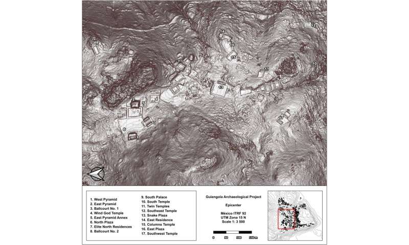
Epicenter of the city. The biggest buildings of the city were found in this area surrounded by the main wall. Credit: Ancient Mesoamerica (2024). DOI: 10.1017/S0956536124000166
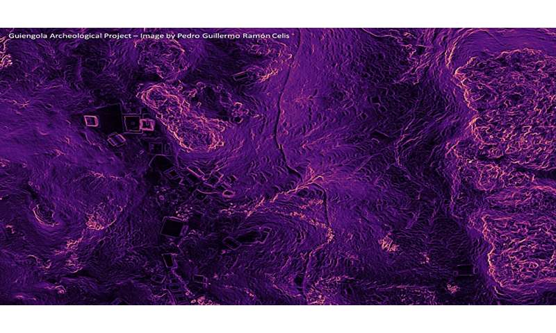
Lidar scan showing the Civic and Ceremonial Center (left) and the commoner areas (right), split by a defensive wall (center). Credit: Pedro Guillermo Ramón Celis
Epicenter of the city. The biggest buildings of the city were found in this area surrounded by the main wall. Credit: Ancient Mesoamerica (2024). DOI: 10.1017/S0956536124000166
Lidar scan showing the Civic and Ceremonial Center (left) and the commoner areas (right), split by a defensive wall (center). Credit: Pedro Guillermo Ramón Celis
"My mother's family is from the region of Tehuantepec which is about 20 km from the site, and I remember them talking about it when I was a child. It was one of the reasons that I chose to go into archaeology," Ramón Celis said.
"Although you could reach the site using a footpath, it was covered by a canopy of trees. Until very recently, there would have been no way for anyone to discover the full extent of the site without spending years on the ground walking and searching. We were able to do it within two hours by using remote sensing equipment and scanning from a plane."
By analyzing the data generated by the scans and using the Geo Analytic laboratory at McGill, Ramón Celis has been able to map the size and the layouts of the remaining built structures and infer their use based on the artifacts found at the locations.
To explore how power was distributed in the city, he has calculated how much building space was given over to elite areas such as the temples and ballcourts, for example, compared to what was built in the areas used by commoners. Ballcourts were built in Mesoamerica for the purpose of practicing a ritual ballgame, and represent both the underworld and fertility, since they are a way of connecting with the ancestors and seeds grow below the soil, where the underworld is found.
Ramón Celis added, "Because the city is only between 500 and 600 years old, it is amazingly well preserved, so you can walk there in the jungle, and you find that houses are still standing… you can see the doors… the hallways… the fences that split it from other houses. So, it is easy to identify a residential lot. It's like a city frozen in time, before any of the deep cultural transformations brought by the Spanish arrival had taken place."
More information:
Pedro Guillermo Ramón Celis, Airborne lidar at Guiengola, Oaxaca: Mapping a Late Postclassic Zapotec city, Ancient Mesoamerica (2024). DOI: 10.1017/S0956536124000166
Citation:
Remote sensing tools yield insights into abandoned pre-Columbian Mexican city (2025, January 29)
retrieved 23 February 2025
from https://phys.org/news/2025-01-remote-tools-yield-insights-abandoned.html
This document is subject to copyright. Apart from any fair dealing for the purpose of private study or research, no
part may be reproduced without the written permission. The content is provided for information purposes only.
A new Nature Physics study has shed light on the long-hypothesized liquid-liquid critical point where water simultaneously exists in two distinct liquid forms, opening new possibilities for experimental validation.
An international research collaboration led by the University of Surrey's Nuclear Physics Group has overturned the long-standing belief that the atomic nucleus of lead-208 (²⁰⁸Pb) is perfectly spherical. The discovery ...
This week, University of Ferrerra researchers reported on the evolution of European skin, eye and hair pigmentation over the last 45,000 years. A re-examination of Galileo space probe data strongly suggests that Callisto ...
A team of materials scientists and engineers at ETH Zurich has developed a light-triggered chemical process for breaking down certain polymers into their constituent monomers. The paper is published in the journal Science.
Thutmose II was the fourth ruler of the illustrious ancient Egyptian 18th dynasty, which included Tutankhamun. Now, the location of his long-lost tomb, one of the last missing royal tombs, has been confirmed by the New Kingdom ...
Two heads are better than one, as the saying goes, and sometimes two instruments, ingeniously recombined, can accomplish feats that neither could have done on its own.
A new study reconstructing extreme rainfall in Arabia has uncovered that rainfall in the region was five times more extreme just 400 years ago, highlighting the need for preparedness amid growing urbanization.
An early-career physicist mathematically connects timelike and spacelike form factors, opening the door to further insights into the inner workings of the strong force. A new lattice QCD calculation connects two seemingly ...
Research from St. Olaf College and the University of Denver, published in Current Biology, found that a parasitic fly in Hawaii has evolved to eavesdrop on the mating calls of Pacific field crickets. The flies were likely ...
Scientists have now mapped the forces acting inside a proton, showing in unprecedented detail how quarks—the tiny particles within—respond when hit by high-energy photons.
A study published in Geophysical Research Letters has challenged the conventional understanding of the relationship between global warming and ocean evaporation. A research team from the Institute of Geographic Sciences and ...
The Standard Model (SM), the main physics framework describing elementary particles and the forces driving them, outlines key patterns in physical interactions referred to as gauge symmetries. One of the symmetries it describes ...
Sweden's Viking Age population appears to have suffered from severe oral and maxillofacial disease, sinus and ear infections, osteoarthritis, and much more. This is shown in a study from the University of Gothenburg in which ...
The ancient peoples of the Philippines and of Island Southeast Asia (ISEA) may have built sophisticated boats and mastered seafaring tens of thousands of years ago—millennia before Magellan, Zheng He, and even the Polynesians.
A team of engineers and physicists at Southern University of Science and Technology, in China, has created a nickel-based material that behaves as a superconductor above the -233°C (40 K) threshold under ambient pressure. ...
A small team of marine biologists at the University of Bristol, in the U.K., working with a colleague from the Regional Research and Innovation Agency of West Papua, Indonesia, has found that wild broadclub cuttlefish adapt ...
Plants & Animals
Feb 21, 2025
0
89
Get Instant Summarized Text (Gist)
Remote sensing using lidar has revealed that Guiengola, a 15th-century Zapotec site in Oaxaca, Mexico, was a large, fortified city rather than just a military fortress. The city spanned 360 hectares with over 1,100 buildings, organized urban layouts, and separate neighborhoods for elites and commoners. The site was likely abandoned before the Spanish arrival, with inhabitants relocating nearby. The findings offer insights into Zapotec political and social organization.
This summary was automatically generated using LLM.
Full disclaimer
Let us know if there is a problem with our content
E-mail the story
Remote sensing tools yield insights into abandoned pre-Columbian Mexican city
Donate and enjoy an ad-free experience
We keep our content available to everyone.
Consider supporting Science X's mission by getting a premium account.